Current projects
Helping to develop a simulation platform to test the earthquake early warning potential of MyShake
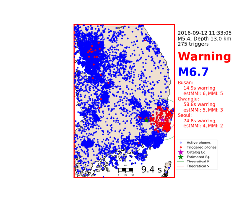
MyShake is a mobile phone app developed at the UC Berkeley Seismic Lab, which uses mobile phone accelerometer data in conjunction with an dense neural network trained to classify earthquake vs. non-earthquake signals, turning users mobile phones into seismometers. This project aims to simulate the ability of hypothetical networks of phones running MyShake to quickly detect and locate large earthquakes. For example, the image here shows a simulation in which we assumed 0.1% of the population of Korea has the MyShake app and tested the ability of this network to issue warnings for the 2016-09-12 M5.4 event. MyShake networks have the potential to be incredibly useful tools for earthquake early warning if they are sufficiently dense.
Mapping seismic noise in urban areas using data from MyShake
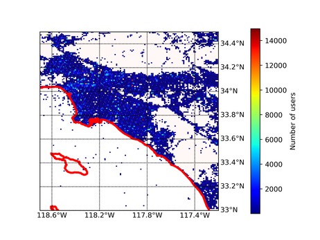
Another exciting MyShake project, started by Asaf Inbal during his time as a postdoc at the Seismic Lab, is an attempt to use MyShake data from urban areas to map sources of urban seismic noise. New versions of the app allow us to remotely 'trigger' users phones so that they record seismic data and send it back to our servers. This data can be used to monitor temporal variation in noise. Once enough data is collected, it may also enable us to detect small earthquakes that are below the detection threshold of traditional seismic networks.
For more details, check out the MyShake website or the website of its founder, Qingkai Kong
Predicting soil moisture content variation from Distributed Acoustic Sensing (DAS) data
Distributed Acoustic Sensing (DAS) is a novel seismic technique that makes use of fiber optic cables to sense passing seismic waves, effectively turning these cables into lines of closely spaced, single component seismometers. At the U.S Army Corps of Engineers' Cold Regions Research and Engineering Lab near Fairbanks, Alaska, a test of this technology was carried out using a grid of cables buried at shallow (~20cm) depth within soil. The system gathered continuous seismic data from July to October 2016 (see this paper for more details). Several soil moisture probes were also located within this grid.
We are attempting to develop a method to predict soil moisture variation from features of the DAS data, using various machine learning techniques that operate on a database of engineered features.
Past projects
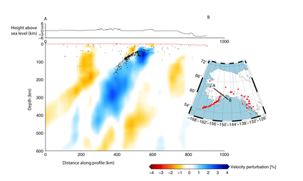
Tomography of mantle structure beneath Alaska
USArray is an ambitious, continental scale seismometer deployment that is currently in the process of moving to Alaska. By 2018, more than 250 broadband seismometers will be deployed across the entire state.
We've been working on teleseismic, local and ambient noise tomography using seismic data from this new deployment to generate 3D images of the crustal and mantle velocity structure beneath Alaska. My PhD advisor for this and all other projects at UC Berkeley is Prof. Richard Allen.
Classification of human activities in the PAMAP2 Physical Activity Monitoring Dataset [link]
This was a mini project undertaken for the Berkeley Graduate Student Data Science Workshop in the summer of 2018. We developed a workflow that involved feature engineering of the PAMAP2 dataset (which consists of biometric data collected by sensors on a subjects' wrist, chest and ankle while they undertake various activities) and classification of the activities.
We investigated the use of machine leaning classifiers such as support vector machines (SVM), random forest and gradient boosting. We also implemented a genetic algorithm for feature selection. Our chosen, turned classifiers achieved hold-out testing scores of >95%.
Building a Lagrangian particle-tracking module for the fluid dynamics code HIGRAD
HIGRAD is a generalized computational fluid dynamics code (CDF) developed at Los Alamos National Lab. As part of a summer internship there, I worked with Eunmo Koo to implement an efficient, parallelized, particle tracking routine that can be used to simulate particle interaction with complex, turbulent flows. This involved programming with MPI and OpenMP.
This has useful and interesting applications in wildfire simulation, pollution modeling and a host of other fields.

Using ASPECT to create mantle flow models
ASPECT is an advanced finite element code developed by the Computational Infrastructure for Geodynamics (CIG). We'll be using it to construct a 3D mantle flow model for the western US and Alaska, using an initial density perturbation field based inferred from tomography.

Investigating fracture propagation in a solid using peridynamics
Peridynamics is a novel approach to the numerical representation of the equations of continuum mechanics. I helped to develop and test a code that uses it to produce high resolution simulations of thermal crack formation in a glass cube. This work was funded by the Lawrence Berkeley Lab (LBNL).
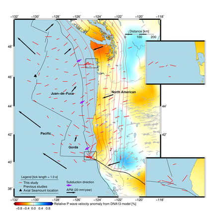
Shear wave splitting using data collected from ocean bottom seismometers (OBS) deployed as part of the Cascadia Initiative
Between 2010 and 2014, an OBS array was deployed across the width of the enigmatic Juan-de-Fuca plate, off the Pacific Northwest coast of the US. Seismic data from these instruments can tell us much about earth structure in the region. In this project, we used shear wave splitting to work out the direction of mantle flow beneath the plate and onshore into Cascadia. The results tell us about how mantle material interacts with the subducting slab in this region.
Modeling the propagation, inundation and run-up of the March 2011 Tohoku tsunami using the finite element package Fluidity-ICOM
Fluidity uses a novel wetting and drying algorithm to simulate the fluid propagation over a previously dry surface. Its ability to solve the incompressible 3D Navier Stokes equations on an unstructured mesh makes it an ideal candidate for tsunami simulation.
Simulations like this are now being run to investigate the effects a hypothetical landslide-induced tsunami in the North Sea might have on the UK coast. Watch this space for the results!
Modeling tidal flow though the Pentland Firth, Scotland
This area is one of the UK's most promising regions for tidal power extraction - the aim of this project was to try to understand the effect that placing a tidal turbine array in the channel might have on sediment transport.
This one also used the Fluidity fluid dynamics simulation package. See the AMCG website for more information on this freely available software.
Journal publications
Venereau, C. Martin-Short, R. Bastow, I. Allen, R. & Kououdis, R, The role of variable slab dip in driving mantle flow at the eastern edge of the Alaskan subduction margin: insights from SKS shear-wave splitting. Geochemistry, Geophysics, Geosystems. 2019. DOI:10.1029/2018GC008170
Martin-Short, R., et al. Seismic Imaging of the Alaska Subduction Zone: Implications for Slab Geometry and Volcanism. Geochemistry, Geophysics, Geosystems. 2018.
Martin-Short, R., et al. Tidal resource extraction in the Pentland Firth, UK: Potential impacts on flow regime and sediment transport in the Inner Sound of Stroma. Renewable Energy. 76 (2015): 596-607.
Martin-Short, R., et al. Mantle flow geometry below the Pacific Northwest: Results from the Cascadia Initiative. Nature Geoscience. 8 (2015): 965-968.
Martin-Short, R., et al. Subduction geometry beneath south central Alaska and its relationship to volcanism. Geophysical Research Letters 43.18 (2016): 9509-9517.
Conference presentations and talks
Martin-Short, R. Porritt, R. Miller, M., Allen, R. Seismic Imaging of the Alaska Subduction Zone: Implications for Slab Geometry and Volcanism. E-lightning poster presented at AGU 2018 fall meeting, December 2018.
Martin-Short, R. Porritt, R. Miller, M., Allen, R. Multiscale imaging of the Alaska subduction zone. Talk given at AGU 2017 fall meeting, December 2017.
Venereau, C. Martin-Short, R. Bastow, I. Allen, R. Mantle Flow at the Edge of the Alaska-Aleutian Subduction Zone from Shear-Wave Splitting. Poster presented at AGU 2017 fall meeting, December 2017.
Martin-Short, R. Porritt, R. Allen, R. Multiscale imaging of the Alaskan subduction zone. Poster given at CIG computational seismology meeting, Lawrence Livermore National Lab, September 2017.
Martin-Short, R. Koo, E. Haskins, K. Robey. R. A generalized particle transport module for HIGRAD. Poster presented at Los Alamos Student Symposium, August 2017.
Martin-Short, R. Koo, E. Haskins, K. Robey. R. A generalized particle transport module for HIGRAD. Talk given to EES-16 group at Los Alamos National Lab, August 2017
Martin-Short, R. Allen, R. Bastow, I. Subduction geometry beneath Alaska and its relationship to volcanism. Talk given at AGU 2016 fall meeting, December 2016.
Martin-Short, R. The structure and dynamics of two subduction zones – Cascadia and Alaska. Invited talk at UCLA Earth Science Tectonics Seminar Series. October 2016.
Martin-Short, R. Edmiston, J. Nakagawa, S. Kneafsey, T. Cryogenic fracturing: Laboratory Visualization Experiments and Numerical Simulations using Peridynamics. Poster presented at AGU 2015 fall meeting. December 2015
Martin-Short, R, Allen, R. Bastow, I., Totten, E.. Richards, M. Mantle Flow from Ridge to Trench Beneath the Gorda-Juan de Fuca plate system. Poster presented at AGU 2015 fall meeting, December 2015
Martin-Short, R, Allen, R. Bastow, I., Totten, E.. Richards, M. Mantle Flow from Ridge to Trench Beneath the Gorda-Juan de Fuca plate system. Poster presented at Ocean Bottom Seismograph Instrument Pool (OBSIP) meeting, October 2015
Martin-Short, R, Allen, R. Bastow, I., Totten, E. Seismic Anisotropy below the Juan De Fuca Plate: Results from the Cascadia Initiative. Poster presented at AGU 2014 fall meeting, December 2014
Martin-Short, R., Piggott, M., Hill, J. Multiscale Modelling of the 2011 Tohoku Tsunami with Fluidity: Coastal Inundation and Run-up. Poster presented at AGU 2014 fall meeting, December 2014